Digitising Woodland Management | Article 2
In the second of our 'Digitising Woodland Management' trilogy exploring digital innovations in woodland management, we focus on drones and their increasing use in forestry. This article joins a further two in the series:
- Digitising Woodland Management: Remote Sensing and Digital Data Processing
- Mobile Technologies and Digital Tools
Drones/Unmanned Aerial Vehicles (UAVs)
Drones have become an increasingly significant technology in forestry in the last two decades collecting bothimagery, video recordings and LiDAR data as well as being used for harvesting. One of the most common uses of drones in forestry is conducting aerial surveys. A drone is flown over woodland and takes high-resolution videos andphotographs, generating large amounts of detailed and precise inventory data about the woodland as a whole and individual trees to enable accurate planning. Existing and developing drone technologies present a number of other opportunities to those involved in the management of woodlands. Data can be recorded and re-recorded frequently or even in real time. Drone technologies could replace traditional measurement tools whilst saving time and improving safety by reducing the need to access potentially unsafe areas. In addition, access to data for previously in accessible areas may be facilitated.
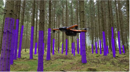
New drone capabilities are being researched and developed. For example, Swedish company KATAM Technologies have developed drones which have advanced navigation and collision systems. This means that they can fly through rather than over forests and take video recordings (see Figure1). Forest owners can avoid entering the hard-to-reach areas but are provided with tree measurement data (tree height, height, diameter) and images to produce inventory reports.
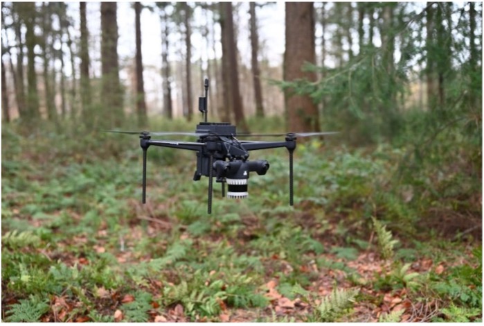
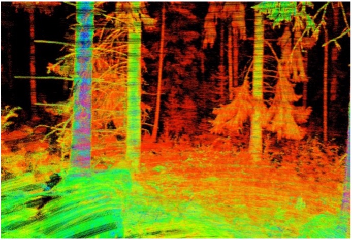
Another example is the Deep Forestry Drones project which developed lightweight autonomous, self-piloting drones which can also fly in between trees below the canopy; but instead, these drones carry LiDAR equipment (see Figure 2). The LiDAR equipment can map individual trees and create a 3D digital map of the woodland. Lidar sensors work by firingpulses of light at an object and calculating the time it takes for them to return to the sensor. This data is then processed into a 3D visualisation of the objects called a point cloud (see Figure 3). Previously it would have been financially unfeasible for humans to map the whole forest in this level of detail as it would mean measuring and marking every tree. This is a significant opportunity presented by this technology. In addition, the Deep Forestry drones are fully autonomous and self-piloting, and this means even someone who has never used a drone before could conduct a survey. A user places the drone on the ground in the forest and pushes one button in order for the drone to then take off and conduct a scan of the surrounding forest and terrain. Although data can be collected by anyone, the need for the data to be processed, presented and explained by a professional is not removed.
However, despite the opportunities which drones currently do and have the potential to provide,there are a number of barriers to their implementation. Cost is a limitation for individuals and limits the viability for smaller woodland owners. Research has been undertaken evaluating the usefulness and affordability of drones in both farming and forestry and in a lot of cases, the cost incurred for individuals relative to the amount of use of the technology that would be required may not be viable and the required scale of the management is not large enough to warrant the use and expense of drones.
This is the case in the UK forestry sector where they are used predominantly by larger organisations to carry out surveys where there are large areas of windblow and for tree top visual inspection surveys to identify symptoms of tree pests and diseases. In line with the innovations discussed here, the Forestry Commission anticipate that in the future drones will be able to penetrate the canopy to reach areas that are often inaccessible on foot, monitor the work of contractors; assess damage following fires; and create 3D images to inform forestry inventories.
As is the case with most cameras and technologies the quality and size of the drones and the resulting data produced is largely reflected in their cost. In this way, whilst innovative drones may be in existence their availability and implementability for local-scale woodland management is restricted. Drones also have limited battery capacities and require charging. The employment and applicability of ‘tethered drones’ to forestry is the subject of research including by companies in New Zealand. The aircraft is connected to an operating box by a thin wire removing the need for the battery to be charged.
It is worth noting that negative cultural perceptions of drones resulting from security and privacy concerns are widespread. Drones used for surveillance have the potential to invade privacy and collect sensitive information due to the unique perspective from which they gather information. They are also able to carry weapons and be used for malicious purposes if they fall into the wrong hands. In accordance with cultural perceptions of drones, drone laws and restrictions differ by country. This is particularly pertinent in the case of autonomous drones such as those discussed above produced by KATAM and Deep Forestry Drones. KATAM’s new recording method was developed as aresult of ADACORSA. ADACORSA is an EU funded project aiming to increase public and government acceptance of autonomous drones which fly beyond the view of the of the operator. The common acronym used is BVLOS – Beyond Visual Line Of Sight. Acceptance of BVLOS regulations would allow drones to fulfil their potential toefficiently fly through areas and capture high quality data. This would benecessary to facilitate the applicability and replicability of similar employment of drones in the context of the UK and more specifically the Northeast and Yorkshire. The topic remains controversial: discussions about the safety (for both humans and animals) and acceptance of drones continue whilst more advanced capabilities of technologies continue to be developed.
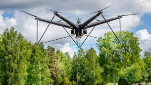
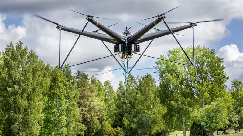
Finally, the use of drones in timber harvesting contexts to save time and money and improve safety is being investigated. Activities such as selective tree cuts on steep, remote areas without endangering people can be achieved. New Zealand company ASG Technologies have a large drone capable of hauling steel rope above felled trees to collect them and carrying out forestry work that would ordinarily take six workers up to an entire day in some six minutes. Despite the potential to save time and money and improve safety, drones with such capabilities are not widely available and this is reflected in their cost. There are cultural concerns about the safety of such technologies: their interactions with animals and their risks when encountering the unexpected potentially causing damage to property or injury to individuals. Swedish company Airforestry have developed a harvest drone: an electric drone 6.2 metres in diameter carrying a harvesting tool (see Figure 4). The light 60kg harvesting tool is carried by the drone to the selected tree. Once in place, the tool grabs the top of the tree, prunes off the branches and then saws off the trunk. The branches and needles fall back to the ground so that their nutrients remain to contribute to continued forest growth. Thereafter, the tool secures the tree so that the drone can carry it back to the nearest road. This is a new and innovative way of carrying out necessary thinning fromthe air to increase the value of the forest without damaging the ground orsurrounding trees. The process is controlled by an operator based nearby. The method is thought to decrease direct CO2 emissions as the harvesting tools use electricity rather than diesel.
Conclusion
This article has introduced a number of drones innovations for woodland management and discussed existing and potential opportunities created by them.
The airborne data from drones has the potential to be employed and combined accordingly with data from satellite technologies, individual tree data collected on the ground using mobile applications and traditional site visits to provide comprehensive and accurate information to those involvedin woodland management. The digital innovations explored have been contextualised in the current UK climate, specifically that of woodland management in the Northeast and Yorkshire, and the barriers to their implementation outlined.
Overall current and future digitisation is anticipated to provide a powerful new dimension to information to inform woodland management where across the UK a lack of site-specific information on woodland inventory and condition is cited as a key barrier to the management of woodland. The technology is likely to help support on-the-ground foresters rather than replace them.
It will be interesting to read this article in years to comeand see if the anticipated rules - for example, widespread acceptance of drones and advancements in technologies and financial viability - have become reality and if woodland management has become more digitalised as anticipated.